
English| EUR
Suggested for you
More currencies
Choose a language
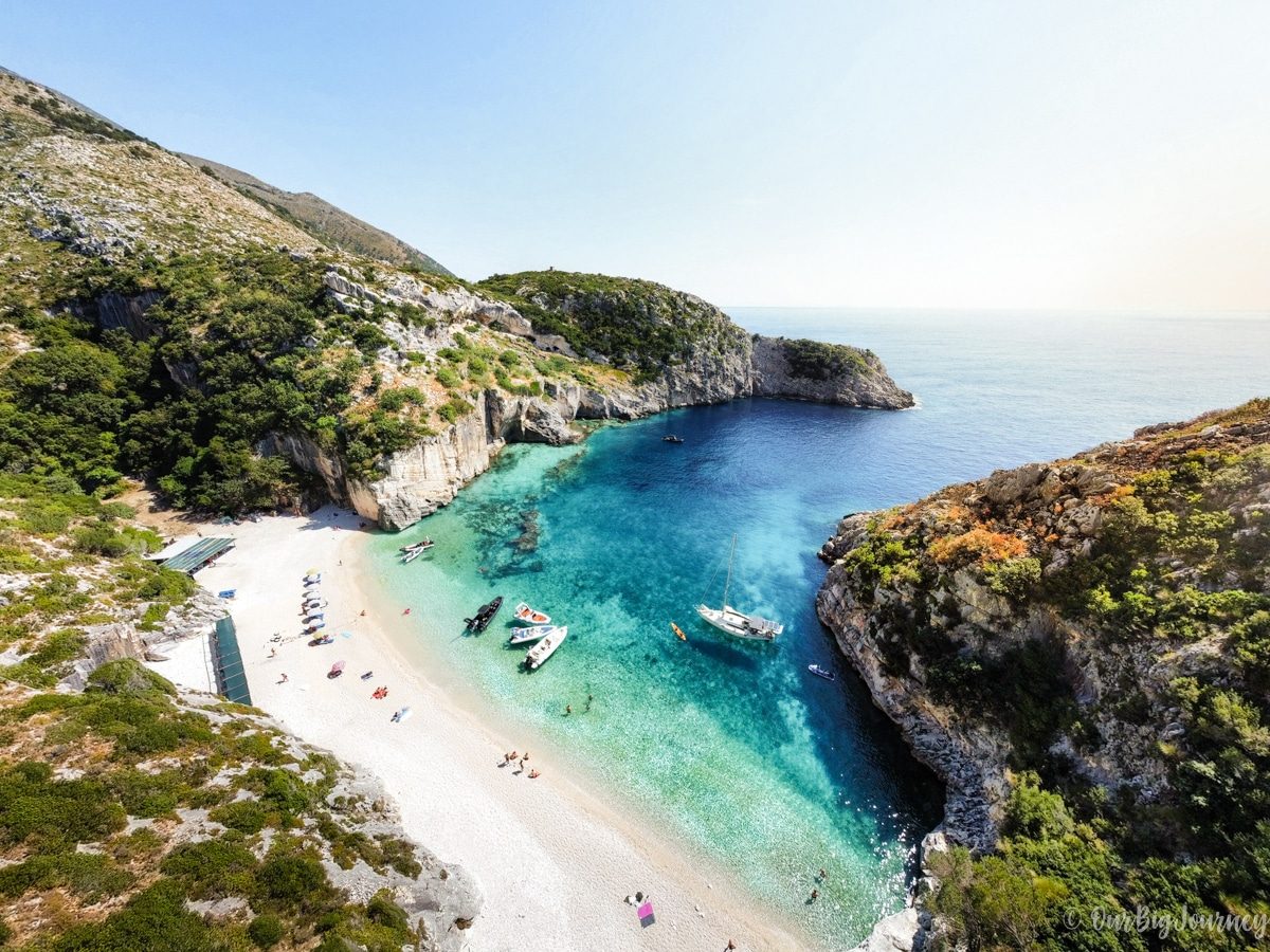
Grama Bay sits on the seaward flank of the Karaburun Peninsula, screened by white limestone cliffs and reachable only on foot or by private boat. This Grama Bay hike guide sets out what the terrain actually demands, how walkers cope with a route that carries almost no signage, and where usable maps come from. It is written for research, not for improvisation on the day.
Quick answer
The Grama Bay hike is a strenuous, largely unmarked walk over dry limestone and loose scree, and it is the only land approach to a cove otherwise reached by boat. Entry to the bay is free and the site is open 08:00–22:00 daily. Heat and exposure, not technical climbing, set the limit; an 08:00–10:30 start is strongly advised.
Grama Bay was a working quarry long before it was a destination. Ancient masons cut limestone from its cliffs and shipped the blocks out by sea. Sailors sheltering in the cove carved their names, their ships and their prayers into the same rock, and many of those inscriptions survive in the walls above the shingle. That history explains the geography a walker inherits. The bay opens west onto the Ionian, sheltered by the Karaburun Peninsula, with no road behind it. Anyone attempting the Grama Bay hike is crossing ground that was never meant to carry foot traffic — only stone going the other way. Difficulty here is a matter of surface, not gradient. The Ceraunian ridge above the water is dry karst: fractured limestone, loose scree, and dense maquis scrub that closes over any path left unused for a season. Shade is scarce and water sources on the ridge cannot be relied upon. The final drop to the shingle is the steepest work of the day, and it has to be repeated in reverse. Fitness matters less than sure footing and heat tolerance. Walkers accustomed to waymarked European trails tend to describe the crossing as physically moderate but navigationally demanding, which is the opposite of what they expect. Mapping is the second problem. The peninsula lies inside the Karaburun-Sazan Marine Park and parts of it remain former military ground, so cartography is uneven and rarely current. Open-source tracks recorded by previous walkers are generally more dependable than commercial trail apps, and every file should be downloaded before leaving the last village, since signal on the ridge is intermittent. Printed maps of Vlorë County often omit the footpath entirely. The practical conclusion is that the trek to Gjiri i Gramës rewards planning rather than instinct. Visitors who want the inscriptions, the water and the quarry scars without the ridge crossing generally take a Grama Bay boat tour from the mainland instead, and treat the walk as an alternative rather than a rite of passage. Those committed to going on foot should read the route and timing sections of this guide before fixing a date, and should measure the day against the site's access window rather than against daylight alone. Approached that way, the Grama Bay hike is a serious but manageable undertaking.
“Difficulty at Grama Bay is a matter of surface, not gradient.”
Grama Bay is located on the Karaburun Peninsula in Vlorë County, Albania. Access to the trailhead requires reaching the remote peninsula via private boat or by navigating the rugged mountain terrain on foot.
Drive via SH8 to Llogara Pass, then continue to the trail access points near the Karaburun-Sazan National Marine Park area
Private vessel departure from Vlorë or Radhimë to reach the coastal trailhead
Hiking from the Llogara Pass area through the Karaburun Peninsula trail system
The best arrival window is 08:00–10:30, as morning arrival ensures calmer seas and avoids afternoon coastal winds.
The best arrival window for the Grama Bay hike is 08:00–10:30, as starting early is essential to avoid peak coastal heat and strong afternoon winds. Planning your trek during the shoulder seasons provides more manageable temperatures for the strenuous ascent.
Warm, 20°C–26°C; moderate sun
Optimal months for hiking with stable conditions and fewer people.
Hot, 28°C–35°C; intense sun
High temperatures make the strenuous hike difficult; early starts are mandatory.
—
Mid-week hikes offer the quietest trail experience and avoid weekend boat traffic at the bay.
Verdict: The best time to hike is during May or September, arriving at the trailhead between 08:00 and 10:30 on a weekday.
There is no admission fee to access Grama Bay. The site is located in the Karaburun Peninsula and is accessible only by private boat or a strenuous hike.
Verdict: A typical adult pays 0 EUR for entry, though significant costs may be associated with private boat transport or guided hiking arrangements.
Grama Bay has no shops, taps or shade on the trail, so everything you need for the walk down and back must come in your pack.
Everything you need to know about grama bay hike
The trail to this remote location is considered strenuous due to the steep terrain and length. Hikers should be prepared for significant elevation changes when completing the grama bay hike.
Yes, the bay is accessible by private boat, which is often preferred over the land route. Opting for a sea-based arrival allows you to enjoy the landscape without the physical demands of the grama bay hike.
We recommend arriving between 08:00–10:30 to ensure calmer seas and avoid afternoon coastal winds. Following this guidance helps you manage your journey effectively before the heat of the day.
Entry to the area is 0 EUR as it is a natural public site. Please note that access is strictly limited to either private boat transport or the challenging trek across the peninsula.
The steep, rugged nature of this path makes it unsuitable for young children or those without advanced fitness levels. Most families choose a sea excursion instead of attempting the grama bay hike.
Yes, many visitors choose to book a sea-based excursion to reach this landmark. If you prefer to avoid the rugged mountain path, viewing the coastline from the water provides a comfortable alternative to the overland route.
Secret Blue Cave & Grama Bay Speed Boat Tour
Read more Tickets & toursGrama Bay Boat Tour Albania
Read more Tickets & toursGrama Bay Boat Tours from Himare
Read more Tickets & toursGrama Bay Boat Trips from Vlore
Read more Tickets & toursGrama Bay Boat Trips from Dhermi
Read more